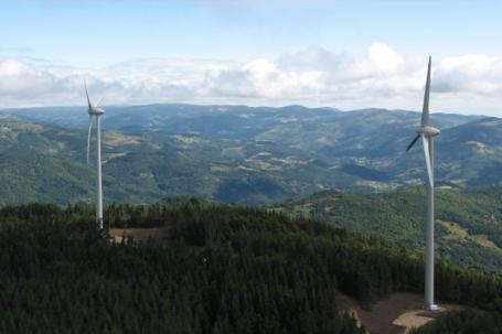
Wind farm on the Saint-Agrève plateau
Chaire Paysage et énergie (ENSP), 2022
The Saint-Agrève wind farm is one of the few wind farms in the forest and this means that the height of the wind turbines is a little higher to get above the trees. As the Citadel site is included in the Monts d’Ardèche Regional Nature Park, particular attention was paid to the layout of the wind turbines so that they would not appear in the foreground of the Ardèche landscape. Inaugurated on 7 September 2007, after 7 years of work, the park of 6 wind turbines is put into service on the site of La Citadelle, at the Serre des Ambalés. In order to make the population aware of the project and the environment, a thematic trail has been set up for free visits. The trail is lined with explanatory panels on the composition of the mechanism of the devices, their operation and their influence on the environment. There is also information on the fauna and flora present. A good example of consultation/transition/enhancement in an unspoilt area.
The agricultural and forestry plateau in a belvedere, between the Ardèche icons
1 - A plateau that is not very well defined at first, a territory where the wind blows
The Saint-Agrève plateau is made up of a succession of diversified open and closed spaces, where moors, fields and woods alternate. It is situated on the edge of landscape units with strong identities, between the terraced landscapes of the Boutières and the flat highlands of the Vivarais and Velay. It is a high plateau, with a highly dissected relief of valleys and hills. Its position to the north of Mont Mézenc gives it a viewpoint over the Ardèche plateau. It is thus defined as a territory of « views » on the landscape emblems of the Ardèche mountains: Mont Mézenc and Mont Gerbier-de-Jonc. The prevailing wind (known locally as the burle) is one of the plateau’s character traits. The winds and the general climate of mountain and Mediterranean influence are defined as harsh, but also invigorating. Saint-Agrève was a renowned « climatic resort » at the end of the 19th century. Despite its character as a « border land », the Saint-Agrève plateau is now claiming its own identity, linked to the negotiations between the desire to develop wind power projects and the desire to assert the Ardèche landscapes at the beginning of the 2000s.
2 - The advance of the forest, the challenge of landscape legibility
The Saint-Agrève plateau is part of a rural area with a tradition of animal husbandry. Since the second half of the 20th century, the landscape has been closing in, particularly with the abandonment of agriculture and the increase in coniferous production forests. The limits of the plateau have become less perceptible. The extension of woodland is a very strong factor in reducing legibility: it gives a compartmentalised reading of the unit and masks the breaks in the slope as well as the landmark elements, in particular the icons Mont Mezenc and Mont Gerbier-de-Jonc visible from the plateau-viewpoint. The Saint-Agrève plateau is therefore a territory with a strong productive vocation, marked in recent decades by the exploitation of wood resources.
3 - The Saint-Agrève plateau as a viewpoint towards the Ardèche mountains
The geographical concept of the plateau has a strong local importance. The local emblem of the Ardéchois Plateau, more commonly known as the Ardéchoise Mountain, is found here. It is a landscape heritage with a strong identity to be preserved, due to its geomorphological specificities defined as remarkable. The Saint-Agrève plateau has less spectacular geomorphological characteristics; its definition is therefore not associated with a desire to preserve a heritage landscape, except in places where there is a view of the Ardéchois Plateau. It is in this context that the wind farm project was born in the communes of Saint-Agrève and Désaignes, positioned on a wooded ridge, at a place called La Citadelle. The landscape identity of the Saint-Agrève plateau integrates contemporary human activities. Forestry and agricultural production are part of the definition of the unit, as well as wind energy activity, thanks to the « burle ». The territory participates in the contemporary need to develop sustainable energy in the era of global warming.
Co-construction of the energy project and the landscape identity of the Saint-Agrève plateau: towards productive links
1 - Public policies and heritage landscapes
The construction of the Citadelle wind farm is the result of a set of territorial and local policies combining energy and landscape concerns, in a territory with a strong morphological and climatic potential for wind energy. In 2001, the DIREN (today the DREAL) built its landscape and energy policy at the level of the Ardèche department, with a wind turbine implantation plan. At the same time, protest movements against the installation of wind turbines were born in the Ardèche Mountains, in the face of the first development pressures. They defend the heritage and environmental landscapes with a strong identity.
2 - The Saint-Agrève plateau, representations of a land of welcome for societal and environmental innovations
The elected representatives of the Haut-Vivarais community of municipalities (now Val’eyrieux) were approached by wind farm developers in the early 2000s. They decided to take the opposite view of these requests, and to take part themselves in a contemporary social issue that was put forward by the departmental authorities. At the same time, they will define together the landscape identity of their territory of action: the Saint-Agrève plateau. They are taking the reins of the project upstream in order to build their own landscape narrative and to control the fiscal and economic spin-offs. Initially, the Community of Municipalities called on the Polénergie association, which later became ALEC 07.
It informs, raises awareness and supports the use of renewable energies for local authorities and developers. The association carries out a technical, environmental and landscape pre-scouting mission for the Community of Municipalities. A selection of potential sites is made, with a referendum of citizen initiative. The Saint-Agrève wind farm project is supported by strong local personalities who are politically and socially involved in the area and its inhabitants. The human element is essential for this handful of convinced people, the project must contribute to the fight against global warming, and carry innovative projects that integrate into the existing territory for a new economy and an enriched identity.
3 - Energy project for « ordinary nature », renewable energy ethics
The Saint-Agrève Plateau could be defined as mainly composed of « ordinary nature », i.e. rural spaces with a productive vocation (production forest, pasture, agriculture) which are not subject to environmental or heritage regulations. As a result, the so-called « nature » areas are linked to the various daily human activities. This « ordinary nature » can be maintained in the context of the wind farm project.
Indeed, the processes of involvement of the populations and the studies carried out at the scale of the Community of communes (and thus of the unit of the plateau of Saint-Agrève which corresponds to its area of influence) allowed a global acceptance of the project. There were no protests, and the wind turbines form a new layer which is integrated into the eminently cultural landscapes, appreciated by their inhabitants because of the sense of balance they offer them. The two phases of studies carried out globally by the DIREN Rhône-Alpes and locally by the Polénergie association have made it possible to draw up a set of specifications and to launch a call for applications to choose a developer.
The specifications set out: The number, power and maximum height of the installations The conditions of the building site The reimbursement of the sum invested by the Community of Municipalities in the pre-diagnosis phase; in particular the cost of the wind measurement campaigns The respect of the landscapes and the « charter » of landscape sensitivities. Following the studies, the Citadelle site was finally chosen. The choice was made for a young local developer: VSB énergies nouvelles (a project that has since been taken over by Boralex). The landscape study for the building permit was conducted by a landscape architect who had already worked on renewable energy and landscape issues. This extensive study is funded by the developer.
Oral and written narratives to bring the evolution of the landscape to life together
1 - Communication, awareness and participation tools
The elected representatives of the Communauté de communes, together with the developer, have put in place a set of tools to inform, raise awareness and involve the inhabitants before, during and after the wind farm project.
Before the project :
-
The layout plan of the wind turbines produced by landscape architects for the DIREN (DREAL), including the map of landscape sensitivities at the scale of the Ardèche department
-
The studies carried out by the Polénergie association, in particular the map showing 8 potential sites for intervention
-
The collective initiative referendum
-
The studies carried out by a landscape architect in the context of the building permit
During the project :
-
About fifty public meetings involving public actors, developers and inhabitants
-
A wind turbine newspaper distributed to the letterboxes of the inhabitants informing them of the evolution of the construction site
-
Visits to the construction site organised with volunteer residents in order to discover the installations in progress
After the project :
-
A thematic interpretation trail in the continuity of the existing communal trails
-
A large part of these actions is financed by the developers, who are concerned with the acceptability of the project. All these actions allow a common social construction of what is a quality landscape and the place of wind turbines in it.
2 - Potential projects according to landscape sensitivity
The wind turbine siting plan drawn up by the DIREN on a departmental scale makes recommendations based on the definition of « landscape sensitivity scales », ranging from a « major » to a « strong » gradient, identifying potential sites for project acceptance and viability.
3 - Selection of wind farm sites in common and in relation to the landscape
The study conducted by the Polénergie association proposes a selection of potential sites. This selection is made by superimposing various constraints (distance from dwellings, heritage sites, classified ecological sites or sites with a strong identity, etc.) and advantages (relief, wind, etc.). The first desire was not to install a wind turbine that would interfere with the view of the Ardéchoise Mountain and the Mézenc-Gerbier mountains.
Each mayor of each commune holds a referendum on whether or not to install wind turbines on the communal territory. This led to the creation of a map showing nine potential sites spread over seven communes.
4 - The « good and beautiful » wind landscape. Wind turbines as a new element of the living environment.
The Citadelle wind farm is located at an altitude of 1196 m, on the highest point of the commune of Saint-Agrève. It consists of six wind turbines. Five are in the commune of Saint-Agrève and one in the commune of Désaignes. The park was inaugurated on 7 September 2007. All the wind turbines produce 2300 kW; each one produces between 2 and 3 megawatts, which is the equivalent of the total electricity consumption of 10,000 families over one year. A landscape designer is carrying out the landscape part of the impact study, which will determine whether or not a building permit is granted. The study focuses on the question of the visibility of the wind turbines and the accessibility of the site. The scale and viewpoints are defined to ensure a harmonious integration.
Part of a production forest is to be used for the turbines. The machines will visually emerge from the forest cover.
The issue of landscape closure does not seem to have been a cross-cutting issue at the time of the project; deforestation was to lead to replanting. Today, one would probably ask whether replanting is a wise choice, in environmental and landscape terms, by examining the potential for open space management. An important part of the study focuses on the issue of visibility. The wind turbines should not be in the frame of vision of the viewpoints overlooking the Mézenc-Gerbier massifs, nor should they be seen from them. The study should enable a « hierarchy of sensitivities » (Mathilde Lecuyer), thanks in particular to the monitoring committees.
The part of the study dealing with accessibility opens up a reflection on the walking routes. The idea is to keep the existing paths around and in the wood, and to integrate the wind turbines into them, while also proposing an interpretation path. A car park used for the wood transporting trailers is redeveloped; it becomes a place for observation and access to the whole project. This opens up the site to the public from a road route, allowing a « reasonable walk » in terms of difficulty with the Citadel loop footpath accessible from the car park.
The forest is used as a visual support for the wind farm. The ridge lines are emphasised, with the two lines of turbines converging on the summit of the Citadel.
These profiles integrate the notions of visual perception and « harmony ». They show that for an identical rotor size, the larger turbine appears the most slender when its base is located behind a 25 to 30 m high vegetation screen. The part emerging from the woodland (the last 55 m of the mast) is almost the same size as the 65 m tall turbine. The visual ‘harmony’ is considered to be better in the case of the taller turbine.
In the context of the wind project, several types of access are defined:
-
Accesses for construction and maintenance of the park
-
Visitor access during construction, secured and marked out
-
Pedestrian access after the works, site visits, walks and hikes
Creating a landscape with wind power: a global Ardèche challenge
1 - The time of the specialists: towards methods of construction of wind landscapes
After the Citadelle wind farm project, the elected representatives of the community of communes and the landscape architect who worked on the impact study were invited to conferences and symposiums on energy, landscape or local governance issues, and presented the Citadelle project in Saint-Agrève, which has become an example. Various reports and studies have been carried out on this project, which show that the steps taken to involve the inhabitants make it possible to have the wind power project accepted, as well as to define a landscape identity recognised by all. Since the Saint-Agrève project, there is a methodological guide for the impact study of wind farms at the national level, which gives a major place to the landscape. It provides many tools to evaluate the inclusion of wind turbines in a landscape, both in visual terms and in terms of identity. Some important notions emerge, potentially inspired by the Saint-Agrève project:
2 - Wind farm developers and landscape: issues of acceptance and links to the landscape
The Ardèche and in particular the territories of the Montagne Ardéchoise and the Plateau de Saint-Agrève, are now part of the Monts d’Ardèche Regional Natural Park. Numerous sites are attractive to wind power developers, due to the climatic and geomorphological conditions; project developers are increasingly present. The different territorial authorities deplore the absence of a real territorial policy at the departmental level. The implementation documents produced by the DIREN (DREAL) or today by the NRP are interesting, but only consultative. They note a lack of really binding decisions, which would prevent projects carried out on an ad hoc basis, without any general reflection, from being implemented. The NRP’s wind power guide, which has been annexed to the Park’s charter since 2014, emphasises the notion of compatibility of projects with the guide and the exclusion of projects in red zones.
The example of Saint-Agrève is a clear reminder that the inter-communal scale is essential, as wind turbines can be seen from afar, particularly due to the geomorphological characteristics of the Ardèche; it is therefore necessary to have a global vision. This vision must also be committed. A lack of commitment on the part of elected representatives and associations leads to the management of energy installations based solely on financial support, which is generally not a guarantee of acceptance by the population.
Références
-
Experience extracted from the guide « Energy transition : towards desirable landscapes » carried out in 2021 - 2022 by the Landscape and Energy Chair of the Ecole Nationale Supérieure du Paysage de Versailles : www.ecole-paysage.fr/fr/node/402