Transport and Inequality in Freetown
Joseph Mustapha Macarthy, Braima Koroma, 2022
Urban informal transport is fundamental in addressing inequality in cities. In Freetown, Sierra Leone, transport not only shapes the spatial spread of people, but it is also an important enabler of social inclusion which affects the wellbeing and socioeconomic condition of residents and hence, inequality. The city is growing fast both in area size and population, but owing to its high density and rugged topography, transport access varies widely among different social groups and places with most of the mobility burden borne by low-and-medium income groups, especially those living in informal settlements that are hard-to-reach places. Owing to the current deficits in the public transport system which climate change impacts will exacerbate, the central government, with support from donors, is carrying out a range of actions to improve the efficiency of the system and to shift the city’s public transport trajectory to more sustainable pathways. But while the city government is also committed to improving mobility in Freetown through its Transform Freetown Plan, it only has a limited role in the management of the city’s transport system. How well the central government will include the city government in making the city’s public transport system efficient, safe and accessible is at the heart of addressing the varying degrees of inequalities and transport injustices faced by the urban poor in Freetown.
À télécharger : transport_and_inequality_in_freetown_by_macarthy_and_koroma_for_gold_vi_chapter_6.pdf (640 Kio)
Introduction: Informal Transport and the Challenge to the Mobility of People and Goods in Freetown
Freetown (Sierra Leone) is growing fast both in area size and total population, but this comes with a lot of mobility challenges to the residents. The city concentrates about 1.1 million people (about 14.9 percent of Sierra Leone’s total pop- ulation) within an area space of 82 km2 (about 1 percent of the country’s total land area) making it one of the most densely settled cities (12,959 inhabitants per km 2 com- pared to 98 persons per km2 for the country) in West Africa. At current rates of population growth, the city is projected to host 1.5 million by 2030 (World Bank 2019; SSL 2016; SSL 2017). Freetown’s primacy, its population size, and the topography (located on a long narrow strip in-between the peninsula hill and the Atlantic Ocean) have implica- tions for accessibility. The hills create a division in access between deprived informal settlements that tend to develop along hills’ slopes, and the low-lying coastal areas and the more well-off areas in the city’s undulating plains. Recent data from Statistics Sierra Leone (SSL 2019) shows that slightly one-third (37 percent) of the Freetown popula- tion was multidimensionally poor in 2017, despite this figure being lower than the national average. The city’s high population density and high poverty levels bring with them a huge challenge to spatial develop- ment (Lynch et al 2020).
Public transport is the dominant means of movement in Freetown. However, the trade is typically infor- mal (85 percent) with the transport sector being the second highest producer of jobs in the city. The concentration of jobs and economic activities in the city centre has implications for movement and demand for public transport (Koroma et al 2018). The city center itself is one of the few places which has benefited from an orderly layout of paved streets and a compact development pattern. Elsewhere to the east and west, the city’s development has been shaped by the rugged stretch of the Western Area Peninsula hills, which has favored fragmented development, while much of the recent growth has occurred along road infrastructure corridors (MLCPE & FCC 2014). The city’s built-up area has expanded at an annual rate of 5.1 percent between 1974 and 2014 with the largest growth occurring between 2000-2014. Within this same period, the city’s population increased from 268,000 to over 1 million (World Bank 2018).
Transport access in Freetown varies widely among different social groups and places. A recent study (Koroma et al 2021) shows that most of the urban poor who live in hard-to-reach areas suffer varying forms of transport barriers and have to walk to the nearest road junctions to take public mini buses, which are relatively cheaper. People living in such locations tend to be lowly paid and occasionally have to walk long distances to their places of work if they cannot afford the transport costs of the day. The spatial spread of services and employment opportunities is already having implications for transport demand across the city. This is worsened by infrastructure deficiency which is having severe constraints on the connectivity of both people and trade.
The Urban Transport System in Practice
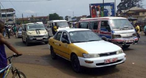
About half of all vehicles registered in Sierra Leone operate in the Free- town area. However, urban mobility in Freetown is characterized by a disjointed public transport which is dominated by paratransit. Public transport is provided through a mix of formal and informal suppliers involving different transport modes. Formal transport consists mainly of government buses which are run by a national operator, the Sierra Leone Road Transport Corporation (SLRTC), providing services for less than 20 percent of the public transport needs. Informal provision, which accounts for 80 percent of the public transport services, is provided through different modes involving a few full-sized buses, mini buses (poda-poda), shared taxis, three-wheelers (kekeh) and motorbikes (okada). The service has evolved organically over time to fill in gaps left by an ageing and declining national operator. It is now the main means of connecting in the city, especially by low-and middle-income households who do not own private vehicles (Kwong et al 2020; Koroma et al 2021: World Bank 2019). During rush hours, passengers can be seen crammed in poda-podas even in hot conditions, but they offer the cheapest way of moving around the town. Nonetheless, most passengers who want to avoid traffic congestion prefer using okadas and kekehs because of the ease to navigate road traffic and unpaved roads, which saves travel time (World Bank 2019; Hitchen 2017; Koroma et al 2021). Often, okadas charge slightly higher prices than kekehs since they are relatively faster.
Only a few areas within Freetown are connected with routed public transport services from the city center. Most of the rapidly growing informal settlements on the hillside (where mostly low-and-middle income groups reside) that are unpaved are largely unrouted. However, accessibility to such locations is ensured through unrouted services which have tended to adapt to the terrain. A recent study identified 124 points across the city where okada and kekeh operators who provide such services converge to pick up and drop off passengers. However, while okadas are able to easily move into hard-to-reach areas, they are usually more accident-prone owing to the hasty and reckless riding styles of the riders (Oviedo et al 2021). However, it is walking that is identified as the main transport mode (especially among low-income groups) accounting for 31 percent to 54 percent of all travel modes. This is true despite the limited and precarious pedestrian infrastructure in the city.
Deficiency of the Public Transport System in Freetown
Several issues have been associated with informal transport, including the unreliability of services, infrequency of trips, limited and uncomfortable sitting conditions, traffic congestion, and dangerous driving. Besides, the road system is poorly connected, leading to circulation problems at the main interchanges and terminals. The generally poor and narrow pedestrian facilities also force people to walk on the streets, which contributes to traffic congestions and chaos. A recent World Bank study shows that nearly all the transport routes are not well-defined with clear schedules to guide passengers. Transport operators are also in constant struggle with police officers demanding bribes at some strategic locations in the city. These problems make movements of people both challenging and frustrating. For the urban poor, movement is especially difficult in the city center, where pedestrian accessibility to sidewalks is obstructed by parked cars or traders who routinely block it with makeshift stalls. In some areas, side-walks are either damaged, missing, or are being encroached on by buildings. Although some primary roads have been rehabilitated, with further rehabilitation work still on-going in a few places, there is a significant backlog of roads needing repair.
Public transport and the constraints of hazards and Climate change risks
Owing largely to its coastal location, its rugged and steep terrain and the wet tropical climate, many roads are exposed to flooding and mud falls. In the city center, the recent rise in floodings has been associated with the narrow drainage ways, which easily get clogged up by uncollected waste (Allen et al 2020). Elsewhere, disaster events are linked to the unplanned growth owing to the rapid urbanization of the city, which forces people to live in at-risk locations. As natural disasters become more frequent and severe, the risk of obstruction to urban transport and road infrastructure by the downslope runoff is real (GoSL 2019). Yet while the Freetown City Council (FCC) is the highest political authority with responsibility to promote development in the city, it does not have a mandate for urban transport. The only power it has is to designate parking areas, charge parking fees and control street traders.
Towards an inclusive and sustainable public transport trajectory for Freetown
Both the central and local governments are currently faced with difficult choices about which spe- cific pathway to go down to resolve the urban transport and mobility problems in Freetown. On-going actions have focused specifically on institutional reforms, including addressing the poor and inadequate road and pedestrian infrastructure, and the inefficient public transport system. The projects have come in diverse forms (such as rehabilita- tion, expansion, or construction of new roads) but with the intent to shift the city away from a car-centred and towards non-motorized development. Recent interventions include the construction of the Hill Station-Regent-Grafton road as an alternative to the traffic-prone Cline Town-Grafton road. As well as the hillside bypass road network, which seeks to connect the East and West of the city by avoiding the routine traffic congestions in the city center (World Bank 2019; Koroma et al 2021). The on-going IRUMP project is among the latest additions which, together with the transport and mobility objectives of the Mayor’s Transform Freetown Plan, seeks to combine improvements in accessibility with promoting economic growth, functionality and liveability of the city. The FCC’s Transform Freetown Plan commits the city government to turning Freetown into a dynamic, efficient and clean city. This vision is in line with current plans by the national government to promote resilient and sustainable transport infrastructure as part of the current National Development Plan (GoSL 2020). However, because of the limited role of the FCC in urban transport management, its activities have focused on reducing conges tion and promoting public safety.
With regards to transport governance, responsibility for road and transport management in Freetown is shared between the Ministry of Transport and Aviation and the Ministry of Works and Public Assets (responsible for road matters). Each ministry works directly with a few sectoral agencies under its super- vision and the traffic section of the Sierra Leone Police. To avoid over-lapping roles, there are plans to set up an independent Urban Transport Authority (UTP) with responsibility to plan and regulate all transport and mobility issues in the city (GoSL 2013). Nonetheless, how far the UTP will ensure the operation of a network of public transport systems that are safe, affordable and efficient is at the heart of addressing the varying degrees of inequalities and transport injustices faced by the urban poor in Freetown (Kwong, 2020).
Références
-
Allen, A., Osuteye, E., Koroma, B. and Lambert, R. (2020) ‘Unlocking urban risk trajectories: Participatory approaches to uncover risk accumu- lation in Freetown’s informal settle- ments’, in Pelling, M (ed) “African Cities: Lessons and Leadership for Integrating Risk into Development, UN-Habitat: Nairobi.
-
Gouvernement de Sierra Leone (2013) Sierra Leone Integrated Transport Policy, Strategy and Investment Plan. www.slurc.org/uploads/1/0/9/7/109761391/sierra_leone_integrated_transport_policy_strategy_and_investment_plan.pdf
-
Government of Sierra Leone (2019) Integrated Resilient Urban Mobility Project (IRUMP) Environmental and Social Management Framework 2019
-
Government of Sierra Leone (2020) Sierra Leone’s Medium-Term National Development Plan 2019–2023. Available at: www.moped.gov.sl/wp-content/uploads/2019/03/Medium-Term-NationalDevelopment-Plan-Volume-I.pdf ). (Accessed: 2 June 2020). Hitchen, J. (2017) Informal transport versus the state.
-
Hitchen, J. (2017) Informal transport versus the state. Available at: gga.org/infor-mal-transport-versus-the-state/
-
Koroma, B., Oviedo, D. Yusuf, Y., Macarthy, J., Cavoli, C., Jones, P., Levy, C., Sellu S. (2021) City Profile Freetown, Base conditions of mobili- ty, accessibility and land use. T-SUM. UCL Koroma, B., Rigon, A., Walker, J and Sellu, S A., 2018. Urban Livelihoods in Freetown’s Informal Settlement. Freetown: SLURC.
-
Kwong, N., Asvanon, R., Clifton, J., Rodríguez, N., Masroor, S.M., Fro- ment, E., Sánchez-Aizcorbe, V. & Osmani, V. (2020). Driving Freetown Towards Enhanced Mobility: Emerg- ing opportunities from health crises for improved access to livelihoods. Group output produced for the Learn- ing Alliance between the Sierra Leone Urban Research Centre (SLURC) and the Environment and Sustainable Development (ESD) MSc Practice Module at the UCL Bartlett Develop- ment Planning Unit (DPU)
Lynch, K., Nel, E., & Binns, T. (2020). ‘Transforming Freetown’: Dilemmas of planning and development in a West African City. Cities, 101, 102694.
-
MLCPE [Ministry of Lands, Country Planning and the Environment]/FCC [Freetown City Council] (2014) Sierra Leone Preparatory Components and Studies for the Freetown Devel- opment Plan “The Urban Planning Project”, Freetown Structure Plan 2013–2028. European Union.
-
Oviedo, D., Okyere, S.A., Nieto, M., Kusi, L.F., Yusuf, Y., Koroma, B. (2021) The social construction of walkability in informal settlements: practices, ingenuity and informality in Freetown.
-
Statistics Sierra Leone (2016), Sierra Leone 2015 Population and Housing Census. Final Report, Freetown, Sierra Leone: Statistics Sierra Leone- sierra-leone.org/Census_2015.pdf
-
Statistics Sierra Leone 2017 Sierra Leone 2015 Population and Housing Census. National Analytical Report Statistics Sierra Leone (2019) Sierra Leone Multidimensional Poverty Index (2019). ophi.org.uk/wp-content/uploads/Sierra_Leone_MPI_2019_final.pdf
-
World Bank Group 2018. Reforming to Create Jobs Economy Profile Sierra Leone March. Washington, DC: World Bank
-
World Bank, 2019. Integrated and Resilient Urban Mobility Project. www.worldbank.org/en/news/loans-credits/2019/06/13/sierra-leone-integrated-and-resilient-urban-mobility-project