Floods: is there such a thing as good urban planning?
Rémy Tourment, Carina Furusho-Percot, October 2015
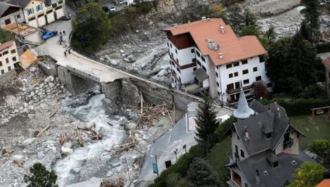
The artificialisation of a territory is only an aggravating factor in the event of flooding.Take the example of what happened in the south of France in October 2015, when some 180 mm of rain fell in three hours, with peaks of 107 mm in one hour. Heavy surface runoff was inevitable. Natural areas simply cannot absorb such quantities of water in such a short time. The problem is therefore less the hazard itself than the vulnerability of the populations facing these situations. However, we can work towards a better-prepared urban environment by accurately identifying negative factors and other, more beneficial ones.
Aggravating factors
Among the most harmful impacts of urbanisation in relation to flood risk are high levels of impermeability and an inadequate rainwater drainage network, combined with the straightening and canalisation of watercourses.
Rainfall is increasingly unable to infiltrate soil that has been sealed by roads and roofs. The drainage network is often saturated by increased runoff or heavy rainfall during exceptional weather events. This accelerates the flow into receiving watercourses which, if channelled, have less space to drain floodwater and cannot slow down the flow rate because they have no meanders. This is the case in São Paulo. The Brazilian megalopolis is facing chaotic urban development and is regularly hit by torrential rains causing severe flooding.
In France, too, some watercourses have been completely channelled and even covered by structures that are undersized for rare or extreme events. This is particularly true of the Paillon in Nice, the Furans in Saint-Étienne and the Jarret in Marseille. The latter was channelled and covered to make way for one of the busiest roads in the city.
Limiting risks
There are two types of urban planning that can limit flood risks: those that reduce (or do not exacerbate) the hazard itself, and those that reduce its impact.
The first type includes urban development projects involving ‘multifunctional’ structures, such as those in the Netherlands. These structures combine protective and environmental functions with urban development functions such as promenades and car parks. They can also be used to move structures away from the water, thereby reducing hazards.
One example is ‘Waterproof Amsterdam’, one of the pilot sites of the ‘Delta Programme’, which proposes a new ‘multi-layer’ approach to flood risk management. This includes a prevention component with dykes and dams, organised development to limit the vulnerability of key urban infrastructure, and finally the implementation of crisis management (evacuation plans, public awareness). The benefits are numerous (landscape, safety), provided that part of the territory is left as a ‘natural’ wetland.
Other examples include urbanisation projects based on floating houses or houses on stilts built in flood-prone areas, two techniques that have been in use for centuries. Examples include the ‘amphibious houses’ found in the Netherlands and, more recently, on an island in the Thames in the United Kingdom. These houses do not require dykes and therefore do not raise the water level. However, it should be noted that building on stilts is effective against flooding but not against earthquakes.
All this applies if, in flood-prone areas (including those protected by dykes), it is accepted that the most dangerous areas should not be urbanised, or even that homes should be demolished (with compensation for their inhabitants). One example is the La Bouillie area in Blois, where a spillway is designed to limit the flow of the Loire in the event of flooding. In 2004, the Blois urban community launched an operation to de-urbanise this area in order to protect residents from the risk of flooding.
Another option is to fill in certain parts of the flood zone to make it non-floodable, as is being considered for some of the Loire valleys (including Orléans and Tours and their populations living in flood-prone areas behind the dykes). Another example is Rotterdam Airport, which can be used as a refuge in the event of massive flooding.
Reducing impacts
When it comes to urban planning that reduces the impact of hazards, there are many solutions, both in terms of housing and networks, such as raising the ground floor, for example. However, these solutions have yet to be widely implemented in construction and over the long term. There is often a cost associated with these vulnerability reduction measures that we are not always prepared to bear. In France, for example, homes built with flood-prone ground floors that were uninhabitable have been converted to make this space habitable.
While urban planning solutions exist, one of the main difficulties remains in how to address the issues: urbanisation is often managed with a short-term vision, whereas flooding is a long-term issue because it is linked to the probability of events.
Sources
-
theconversation.com/inondations-y-a-t-il-un-bon-urbanisme-48772
-
Rémy Tourment, Ingénieur-chercheur, spécialiste des digues de protection et barrages, Inrae
-
Carina Furusho-Percot, Ingénieur de recherche en prévision hydrologique, Inra