Quito - Protecting ecosystems to reduce its carbon footprint
Assessment of the territories’ climate action
2018
Association Climate Chance (Climate Chance)
Since 2015, the Climate Chance Association has been involved in the mobilization in the fight against climate change. It is the only international association that proposes to bring together on an equal footing all the non-State actors recognized by the UN. In order to strengthen their action and to give credibility to the climate stabilization scenarios, the Climate Chance Association launched in 2018 a Global Observatory of Non-State Climate Action, which aims to explain the evolution of greenhouse gas emissions, by crossing national public policies, with sectoral dynamics, private actors’ strategies, local public policies, and actions undertaken by the actors of the territory. In order to analyse the coherence of local public policies, Climat Chance proposes an assessment of « territorial mobilisations » through selected examples of cities and regions. Here, the city of Quito.
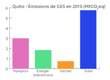
In 2015, the emissions of the metropolis of Quito were 5.8 MtCO2eq, distributed as follows: 52% from transport, 35% from buildings and 13% from waste (C40). Quito, one of the capitals most involved in the community climate networks (C40, ICLEI, 100 cities) is implementing real public investments in this direction. Over the last 4 years, Quito has invested between 10 and 12% of its overall annual budget in actions related to adaptation and reduction of its emissions (2015 Action Plan).
ACCELERATED MODERNISATION OF MOBILITY
Projections up to 2025 assume an annual growth rate of 1.6% for public transit trips and 2.5% for private transportation. This is an opportunity for the metropolis of Quito to think about its mobility strategy. In 2011, 69% of trips were made by bus and 31% by private car or taxi. To improve the fluidity of its system and prevent rising demand, many projects are underway : A first metro line of 22 km is under construction and is expected to be operational in the second half of 2019. The city is also extending to the north its network of electric trolleys and expressways (BRT) initiated in 1995 and today the most widely used system, with a 4% increase in ridership between 2014 and 2018. These new stations are connected to the future metro to provide multimodal transport. Finally, Quito is seeking to promote non-motorized modes of transport, giving priority to pedestrians, cyclists and public transport users : it has recently pedestrianized 8 streets in its historic centre and 3 others are being pedestrianized in 2018 (El Comercio). Its action plan evaluates the reduction potential of its strategy at 100,000 tons (or 0.1 MtCO2) per year, with many benefits related to the air quality of the metropolis.
PROTECTING ECOSYSTEMS, A CHALLENGE FOR THE METROPOLIS OF QUITO
More than 60 per cent of Quito’s high-altitude territory is covered by vegetation, and 56 per cent of its natural vegetation is considered vulnerable to climate change, including changes in temperature and precipitation, as well as increasing population pressure (C40 2017). In response to these challenges, Quito launched a territorial management system for protected areas in 2007, integrated into the national system of protected areas. In order to achieve its objective of reducing its emissions by 5% per year, the city thus intends to manage the surrounding ecosystems as an integral part of its planning, including collaborative environmental governance between several actors in the city in order to enable sustainable land management in all sectors (farmers, tourists, communities, etc.). Its geographic information systems (GIS) allow it to observe the evolution of deforestation and prioritize the most vulnerable ecosystems to ensure the continuity of ecosystem services and natural resilience. Today this system has enabled the establishment of 6 protected areas, a priority intervention area and an ecological corridor representing a total of nearly 175,000 hectares (SMANP). By 2017, the city was attempting to reclaim 60,000 hectares of previously degraded land, which could sequester about six million tons of CO2 once restored and contribute to its 2025 (C40 2017) targets.
AN APPLICATION TO RAISE AWARENESS AND INCLUDE CITIZENS IN THE PROCESS
The Ministry of the Environment in Quito has developed fun and easily accessible tools to measure its carbon footprint and its equivalent in water consumption, depending on the activity carried out. (Action Plan 2015).