PAP36 - The profession of landscape designer
January 2020
Le Collectif Paysages de l’Après-Pétrole (PAP)
Anxious to ensure the energy transition and, more generally, the transition of our societies towards sustainable development, 40 planning professionals have come together in an association to promote the central role that landscape approaches can play in land-use planning policies.
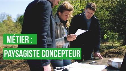
In this article, Claire Gautier, landscape designer and urban planner, co-founder of the Folléa-Gautier agency, presents the profession of landscape designer.
To download : article-36-collectif-pap-cg.pdf (3.8 MiB)
Landscaping, landscaper
Only three small letters distinguish between the words « landscape » and « landscaper ». And yet, in common parlance, an abyss separates them. The whole difficulty of a profession lies there, on either side of this chasm of confusion and ignorance. The word « landscape » easily evokes varied universes and contrasting scales. Depending on the case, we speak of rural, natural, urban, forest or industrial landscapes. The landscape can be immense or intimate. It can be adorned with an infinite number of adjectives depending on the mood of the person who perceives it: luminous, green, delicate; but also pure, minimalist; and, at the other end of the spectrum: dark, disturbing, chaotic.
Beyond the meaning of « landscape painter », the word « landscape painter », on the other hand, appears quite narrow in its commonly accepted meaning: it is still supposed to denote the person who draws and maintains parks and gardens, as if the profession had not evolved over time 1. In reality, the landscape gardener has long since been playing hooky, crossing the wall that encloses the garden to reach the landscape in its infinite diversity: a garden that is now planetary.
In 2016, the law « pour la reconquête de la nature, de la biodiversité et des paysages » (for the reconquest of nature, biodiversity and landscapes) recognizes this fact when it introduces the term « landscape designer » in its article 174. However, a wall of incomprehension continues to exist about this profession, which is still unknown to the public, to almost all elected officials and even to the world of planning. This lack of understanding of the profession of landscape designer is detrimental to the health of the country at a time when the ecological transition calls for a profound change in our lifestyles and living environments. Let us therefore deploy the range of skills and activities of the landscape designer to show how they bring creativity and quality to the development of a post-oil era territory.
At the crossroads of disciplines
To be relevant, any intervention on the territory is based on a reading of the landscape that is both scholarly and sensitive in order to decipher its composition, its values and its weaknesses. The landscape designer therefore calls upon scientific, historical, sociological, economic or artistic disciplines from a wide range of specialists and promotes the transdisciplinary dimension of landscape. Combined together, these references help to build a project based on a solid argument as well as on the designer’s inventive capacity. This coupling of anchoring and creativity is the foundation of the landscape approach.
The natural characteristics of a landscape can be explained by its physical geography, which brings together many disciplines such as geology, geomorphology, pedology, but also hydrography and climatology. Their identification also involves environmental and systems disciplines such as ecology. Each of these disciplines brings elements of understanding on its formation, its evolution and its possible transformation. Landscape development of a valley bottom requires precise knowledge of the nature and permeability of the soils (pedology) and the underlying rocks (geology), the diversity of the fauna and flora and their local dynamics (ecology). The recovery of the banks will take into account the hydraulic regime of the river and the risks of flooding (hydrology). Finally, the consideration of global warming (climatology) invites to choose a flora capable of resisting more brutal meteorological phenomena, drought peaks or tempestuous episodes.
In the same way, questioning the history of a place and understanding its progressive constitution can be decisive for the project. It is important to understand how landscapes have evolved over time and how people have acted on them. History and even archaeology are then called into play. A rural landscape as it stands today is almost always the result of a long process of transformation due to a succession of human activities. Knowing that this forest did not always exist but that it appeared as a result of agricultural decline allows us to desecrate this natural space somewhat or to imagine its possible evolution.
Nourishing the process of a landscape project by the contributions of sociological analysis makes it possible to situate the actors of this landscape whose lifestyles shape and build it (urban planning). These disciplines also help to apprehend changes in mobility behaviour. Urban landscapes are complex places where a multitude of functions (housing, work, travel, meetings, leisure), a multitude of people (families, singles, workers, delivery people, elderly people) and a diversity of spaces necessary for living together (housing, offices, facilities, public spaces) coexist. This accumulation sometimes creates imbalances likely to cause discomfort or conflicts that must be analysed in order to repair, rehabilitate, enhance or redevelop the city. Analyzing the effects of the cut made by an urban motorway in the heart of a metropolis to the point of making it impossible to link one district to another, understanding the consequences and nuisances that road traffic creates in terms of health for the neighbouring populations makes it possible to rethink the place of infrastructure in the city and to imagine possible alternatives.
Economic logics permeate our landscapes. The commercial and industrial economy is unashamedly displayed on the fringes of our cities; the agricultural economy shapes our countryside; the tourist economy marks our coastal coasts, our mountains and our heritage cities; the energy economy weave and punctuates our territory. In order to act in the landscape, knowing how to mobilise economic determinants is essential. The replanting of a bocage requires farmers to redraw the boundaries of their plots: they will decide whether it is in their interest to manage these linear woodlands. It is therefore necessary to organise the mutualised management of these areas and/or develop a biomass processing industry in the form of wood energy or timber. The landscape gardener is keen to understand local economies and to identify the levers by which his project will make sense in real life so that the management of the site is as sober as possible.
Finally, it is essential to take an aesthetic look at the landscape. If the « beautiful » is the object of subjective appropriation, this appropriation is also of a cultural nature. Linked to our collective memory and to legacies, it can thus be shared. To speak of the quality of a landscape is to evoke its harmony, a coherent composition that makes sense in its environment and for a given community. The quality of a rural landscape may be the silhouette of a perched village with a bell tower marking the crest line. No one can claim the composition of such a landscape: it is a common work, built year after year by men, which must be recognised as such and must also be able to evolve. Its protection is not an end in itself, for how can reality be frozen forever? In order to build living landscapes, the project approach involves a creative process based on a drawing that draws on sensitive values in order to sublimate them.
By bringing together all these disciplines, by questioning them through the prism of landscape, the role of the landscape designer is similar to that of a generalist capable of clarifying their complexity in order to act on the territory while maintaining a fair balance between economic, environmental and social values.
The range of scales
The landscape gardener can work on the layout of a canal, the creation of a forecourt, the study of an eco-neighbourhood or the drafting of a departmental landscape atlas. From planting a garden to drawing up a territorial coherence scheme (SCOT), the landscape gardener’s field of action is wide and varied. With experience, the landscape gardener gradually discovers its extent.
Seven categories can be distinguished in the scales of his intervention. Each of these categories corresponds to a range of orders of a different nature.
In the category of gardens, there are assignments for the design and monitoring of work on private gardens, public parks, golf courses and other sports and leisure areas.
At the level of public spaces, the orders relate to the design and monitoring of works in non-built public spaces, urban or rural. This may involve the development of squares, streets, avenues, boulevards and quays, the organisation of soft traffic, parking lots or the development of cemeteries.
These first two categories generally cover project management missions where the landscape designer is responsible for the entire design and monitoring of the work. When necessary, he joins forces with other project managers, designers or engineers, lighting designers, ecologists or VRD engineers (roads and various networks).
The scale of operational urban planning brings together even more varied missions. It includes urban programming, urban project management of eco-neighbourhoods, urban planning, concerted development zones (ZAC), urban renewal within the framework of the ANRU, revitalisation of urban centres, (re)composition of peri-urban spaces, promotion of urban agriculture or rehabilitation of industrial wastelands. Complex orders require the composition of multidisciplinary teams associating architects, town planners, sociologists, depending on the order, of which the landscape designer may be the representative. Depending on the stage of the project, the missions can be upstream, at the programmatic or feasibility stage, with assistance missions to the project owner. They can also call for urban project management or complete project management missions. These long-term commitments call for a framework agreement procedure enabling the market to evolve according to the project’s requirements. The creation of an eco-neighbourhood can extend over more than ten years: the presence of the design team ensures its continuity and consistency over time. The design team is often the only one to know its origin, its foundations and its evolution, where the managers and technicians of the contracting authority have been renewed throughout the project.
The scale of major infrastructure concerns « major projects »: creation of roads and motorways, railways and stations, tramways and tram-trains, multimodal interchange hubs, canals and ports. They may also involve energy production or transport sites, quarry openings or their rehabilitation, or city entrances and commercial urban planning to be rehabilitated. These major projects require a territorial vision as well as a transdisciplinary approach. They call for drawing skills so that the project’s integration into the landscape is obvious. The design work integrates back-and-forth meetings with the engineers to share the complexity of the operation in all the fields concerned: geometry, earthworks, structures, hydraulics, noise protection, natural environment, various equipment, management and operation. A specific talent is required so that, through mediation, consultation and coordination, the project is accepted by all those involved. On the Seine North Europe Canal project, a blockage was thus resolved from the outset thanks to consultation workshops where photomontages, aerial views and perspectives on the territory were presented. As with operational urban planning projects, the missions can take place upstream, in the programming of major infrastructure projects, on an ongoing basis through assistance to the project owner, or downstream in project management.
The scale of natural, cultural or rural areas groups missions for the preservation, enhancement and management of natural heritage sites, around a monument or historic site or in the countryside. It may involve defining a sensitive natural area (ENS), applying the Coastal Law or the Mountain Law, carrying out a major site operation, labelling a major site in France, enhancing heritage sites (UNESCO properties, listed sites, historic monuments, remarkable heritage sites) or specific or characteristic landscape qualities, and drawing up the associated management plans. It may also involve supporting players in the agricultural or forestry world in the qualitative and sustainable management of their farms. All of these missions cover analysis and synthesis work and the proposal of actions to be implemented. Calling for a transdisciplinary approach, these complex and often conflicting issues require a capacity to listen and summarize during mediation or consultation workshops that the landscape designer can handle.
The planning approaches the scale of the territory. The « large landscape » can include large infrastructures such as natural, cultural and rural areas. Planning develops what are commonly known as urban planning documents. These regulatory documents are often produced by landscape designers whose approach to planning is of increasing interest to communities. Entering into a local intermunicipal urban plan (PLUI) or a territorial coherence scheme (SCOT) « through the landscape » is a way of giving a concrete meaning to technical documents that must be linked to the reality of the territory. Conducting workshops and organising field visits to create a shared perception of the landscape so that its fundamental values can be incorporated into the sustainable development and development plan (PADD): these are all effective prerequisites for taking elected representatives on the long adventure of creating or revising a PLUI or SCOT. Thanks to the landscape approach, the SCOT will become a territorial project. Elected representatives are in constant contact with the territory and understand this: today, all planning documents can be approached through the landscape approach, whether they are Sraddet, SCOT, PLUI, PCAET or SMVM 2. Each of these documents covers scales, sometimes very large, that landscape designers are accustomed to.
The scale of the large territory concerns non-regulatory documents covering large areas. These knowledge and diagnostic documents feed the policies to be implemented in terms of planning. They include landscape atlases, landscape plans, landscape charters, territorial workshops, cultural and tourism development plans, major metropolitan projects, rural development plans and, perhaps in the future, other territorial landscape projects dealing with renewable energies, sobriety, efficiency and biodiversity. Like planning documents, these documents aim at long-term orientation. The landscape approach provides solid knowledge and arguments to accompany territories in their evolution and changes: landscape atlases can provide the basis for a landscape policy on the scale of a department or a region. Like territorial workshops, landscape plans and development schemes for tourism, culture or rural areas define strategies and roadmaps for the coming decades by drawing up action programmes. Led by landscape designers supported by specialist skills, these documents provide inventive proposals about the future of our territories, in a context of ecological and social transition.
A nesting of scales
There are no partitions to separate the different missions of the landscape designers. In the case of the urban programming of an eco-neighbourhood that includes the development of public spaces, operational urban planning is combined with project management for these public spaces. In the same way, when the actions of a territorial workshop find their regulatory translation in a SCOT, large territory and planning will be naturally articulated. During the elaboration of the planning and programming orientations (OAP) of a PLUI, planning and operational urbanism are associated in a sort of cross-fade that leads the landscape designer to permanently articulate one scale to the other, from the large territory to the plot.
The landscape approach at the service of major contemporary challenges
The landscaping approach led by the landscape designer is an innovative project combining consultation, creativity and territorial anchoring. The singularity of this global approach allows the landscape designer to be a force for proposals in the face of the major challenges of our societies. By favouring natural and inexpensive solutions whenever possible, the landscape gardener contributes to a more sober and sustainable economy. By carrying out initiatives to reclaim, restore or requalify, he revitalizes and strengthens the attractiveness of the territories. By designing urban planning that is anchored in the sensitive reality, they improve the quality of life and promote good living together. By integrating the spirit of place as a fundamental value of the project, it is based on the memory of the places and the people who built it. By taking into account uses, it designs shared, negotiated and mutualised public spaces that strengthen social cohesion. By offering natural spaces in the city, it contributes to the well-being and health of the population. By reorganising mobility in favour of soft and active transport, it encourages behavioural changes in urban transport. By making city surfaces more permeable, it prevents natural disasters linked to excessive soil artificialisation and reduces the very heavy costs of repair and compensation (prevention of flooding and soil erosion, rainwater management). By designing public spaces with abundant vegetation, it reduces the effects of global warming and effectively regulates the temperature in cities. By re-establishing ecological corridors, it restores life and fights against the loss of biodiversity.
As a designer, mediator, facilitator, researcher, teacher, teacher, adviser to government departments 3, NRPs or municipalities, the landscape gardener plays an essential role in the construction of tomorrow’s world. The profession of landscape designer is not defined once and for all. Like the landscape that is its subject, it grows richer and more complex with the passage of time. In response to the aspirations of citizens and the challenge of the great transition, this profession integrates more and more knowledge and creativity. It is urgent to make it known and recognized in order to move from the logic of planning and equipment to the landscape approach that can transform the country and territories into as many shared, effective and harmonious post-oil landscapes.
1 Dictionaries have remained stuck on this restrictive meaning which refers only to the source of the trade. The recent online dictionary Lintern@ute defines a landscape gardener as « the person who draws up plans for gardens and parks ». The Larousse proposes two expressions: « (architect) landscaper, an agricultural engineer specializing in the design of gardens and green spaces », and « landscape gardener, a gardener who designs gardens, such as the gardener or landscape architect ». For its part, the Centre des ressources textuelles et lexicales (CNRTL), stamped CNRS, remains as narrow in defining the landscape gardener as: « (architect, draftsman, gardener) landscaper. (architect, draughtsman) who designs, (gardener) who creates and maintains parks, ornamental gardens, property surrounds ».
2 SRADDET: Schéma régional d’aménagement, de développement durable et d’égalité des territoires; SCOT: schéma de cohérence territoriale; PLUI: plan local d’urbanisme intercommunal; PCAET: plan climat-air-énergie territorial; SMVM: schéma de mise en valeur de la mer.
3 Text inspired by the brochure « Why use a landscape designer? « Ministère de la transition écologique et solidaire (MTES), Fédération française du paysage (FFP), December 2019.