Planning the adaptation of the Kerkennah archipelago to the effects of climate change
March 2021
Agence pour l’Environnement et la Maîtrise de l’Energie (ADEME)
The Kerkennah archipelago, a flat, low-lying island group in Tunisia, is acutely vulnerable to climate change. Rising sea levels—accelerated by subsidence—threaten to submerge 56% of its 15,300 hectares by 2100, fragmenting the land into smaller isles. This endangers traditional fishing (a key economic activity), coastal ecosystems like Neptune grass meadows, and freshwater resources through saltwater intrusion.
To address these risks, Tunisia’s Coastal Protection and Development Agency (APAL) led two initiatives: updating the Integrated Coastal Zone Management (ICZM) Plan (2014–2015) and designing a Marine and Coastal Protected Area (MCPA) management plan (2017–2018). These projects prioritize participatory governance and ecosystem-based adaptation, offering a model for climate-resilient coastal planning in the Mediterranean.
To download : capitalisation-cc-adaptation-practices-mediterranean-011449b-projectfolio-en.pdf (3.2 MiB)
How does this initiative contribute to the territory’s adaptation to climate change?
The Kerkennah archipelago is very vulnerable to rising sea levels
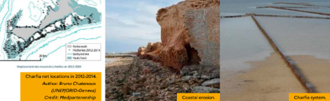
Rising sea levels, in particular due to subsidence, are likely to accelerate the processes that are already visible in the Kerkennah archipelago: saltwater intrusion into the water table, increasing coastal erosion, soil salinisation and the expansion of sabkhas (salt flats). Since the archipelago’s 15,300 hectares are flat and include wetland zones, this landform is expected to split into several isles. By 2100, 56% of the island will be threatened by rising sea levels (APAL, 2016).
Sea-based socio-economic activities are threatened
The main economic activities on Kerkennah are fishing, tourism and agriculture, and these are now threatened by the changing climate. This is particularly true of fishing, which is mainly based on traditional techniques (fishing enclosures known as « charfia » and shore fishing), and is thus severely threatened by rising sea levels.
The areas devoted to this activity, which is mainly carried out in the shallow waters of the Kerkennah archipelago, are expected to decrease due to rising sea levels. The fragmentation of the archipelago into a larger number of isles is likely to modify sea currents and uproot Neptune grass meadows, which will jeopardise small-scale fishing and in turn threaten the food security of local island communities.
Planning must take into account climate change
There is still only limited knowledge about the impacts of climate change on the Kerkennah archipelago. These initiatives aimed to take these impacts into account in planning documents. Although this is crucial to enable adaptive coastal management, many factors still prevent the effective inclusion of climate change in planning (lack of resources for monitoring and evaluation, lack of scientific data to define indicators and carry out assessments, etc.).
Involvement of the local population in planning and implementation
A participatory approach played a central role in the successive projects carried out in Kerkennah. In 2014-2015, these initiatives aimed to improve the integration of climate change issues into ICZM, and in 2017-2018, they focused on drawing up a management plan to set up a Marine and Coastal Protected Area (MCPA). The continuous involvement of stakeholders enabled the various planning documents to be co-constructed, thus ensuring greater community ownership of the underlying issues and the measures to be carried out. The involvement of various actors, and their level of interest throughout the participatory workshops during which the successive management plans were drawn up, demonstrates increasing awareness about the implications of climate change for coastal planning and the importance of local mobilisation.
Project spotlight
Goal
To provide the population of the Kerkennah archipelago with the appropriate planning documents and governance to improve their resilience to climate change.
Background
The Kerkennah archipelago, which is situated in the Gulf of Gabès, comprises two main islands, Chargui island (or Grand Kerkennah), Gharbi island (or Mellita), and a cluster of twelve isles. From an administrative point of view, Kerkennah is a delegation within the Sfax governorate.
The main economic activity in the archipelago is fishing, using traditional fish trapping and capture techniques. However, fishery resources and marine ecosystems (Neptune grass meadows) are threatened by illegal, unsustainable fishing practices (trawling). Yet these ecosystem services are of vital importance to the local economy, since they contribute to the population’s food resilience. They also play a crucial role in climate change adaptation (Neptune grass meadows stabilise the seabed and the shoreline, which limits the impact of marine erosion). On land, vegetation also plays an important role in limiting marine erosion and soil salinisation.
In addition, the island is also facing waste management and sewage treatment issues, as well as seasonal population pressure due to tourism (15,000 residents in winter and up to 200,000 residents in summer).
History of ICZM initiatives in Kerkennah
The Integrated Coastal Zone Management plan for the Kerkennah archipelago was updated by the Coastal Protection and Development Agency (APAL) in 2014-2015, as part of the ClimVar project. This regional project to integrate climate change and variability into national ICZM strategies is a complementary initiative to the MedPartnership project, which involves 11 Mediterranean countries and is funded by the Global Environment Facility. In 2017-2018, the preparatory study for the north Kerkennah isles management plan was also carried out by APAL, in partnership with the Regional Activity Centre for Specially Protected Areas (SPA/RAC). This formed part of the umbrella MedMPAnet programme (Regional Project for the Development of a Mediterranean Marine and Coastal Protected Areas Network).
This initiative, which followed in the footsteps of the ClimVar project, mainly focused on drawing up the ICZM plan for the future Kerkennah MCPA (based on the zone identified in the 2015 recommendations). Consultation processes were carried out in the form of 3 participatory workshops in 2014-2015 and 5 workshops in 2018-2019, as well as gatherings, interviews and meetings with local stakeholders.
Technical description
Several recommendations were made in successive planning documents, which included the following suggestions:
-
Control and regulate fishing activities;
-
Implement awareness raising programmes for local communities and local authorities on the importance of conserving ecosystems;
-
Implement map-based monitoring of the size and status of ecosystems (especially seagrass meadows);
-
Create Marine Protected Areas (MPAs) and protected zones;
-
Install artificial reefs and anti-trawling devices in sensitive areas, to safeguard the reproduction of marine organisms and protect seagrass meadows from trawling activities;
-
Prepare a tourism and ecotourism development plan for the whole territory and for protected areas; etc.
Some of these measures are currently being carried out, mainly thanks to the framework provided by planning documents and the instatement of appropriate governance.
Territory concerned: Kerkennah archipelago (island territory)
Initiative holders: Tunisian Coastal Protection and Development Agency (APAL)
Partners:
-
Initiative 1: GRID-Geneva, GWP-Med, Plan Bleu
-
Initiative 2: UNEP, SPA/RAC
Calendar:
Preparation of framework documents for planning:
-
Initiative 1: 2014-2015
-
Initiative 2: 2017-2018
Human resources: Mobilisation of local stakeholders (civil society and associations), involvement of national and decentralised agencies and institutes (INSTM, ONAS, ANPE, ONTT, INM, INAT, etc.)
Financial resources:
-
Total budget for Initiative 2 (planning study only): €32,000
-
Implementation of Initiative 2: Currently seeking funds
What are the tangible results?
Protecting ecosystem services, a strategy to adapt to climate change for Kerkennah
Today, the approaches available to protect the coastline against rising sea levels and erosion include « hard » techniques (rip-rap, dikes, breakwaters) or more « flexible » techniques (sand fencing, beach replenishment, etc.). However, these flexible techniques are not yet used very much in Tunisia and « soft » solutions, like sand fencing, are not feasible in Kerkennah due to strong sea currents that undermine the stability of such structures. For this reason, the definition and implementation of an ICZM plan, in conjunction with the delimitation of a MCPA, are the best methods to protect the services provided by marine ecosystems and thus improve the resilience of Kerkennah’s resident communities.
Governance to implement the Kerkennah MCPA management plan is currently being set up
A local Consultation Committee, comprising community representatives, NGOs working at the site and professional organisations, is due to be set up by the end of 2020. This Committee will advise the Management Unit on the establishment, revision, amendments and implementation of the management plan.
The Kerkennah MCPA Management Unit, which will be formed by APAL officials, will be responsible for coordinating the stakeholders within this Committee. A co-management system involving APAL and a local association (ideally a fishermen’s association) is being considered for this Unit, to ensure closer coordination between the Management Unit and the Consultative Committee. To this end, a dedicated APAL unit for the Kerkennah archipelago will open in 2020.
Priority activities to be carried out
Activities to be carried out before the end of 2020 have been prioritised. These include:
-
Marking the outer limits of the whole zone to be protected;
-
Launching surveillance activities to prevent trawling;
-
Carrying out awareness activities with fishermen (workshops and training);
-
Carrying out a feasibility study on the installation of artificial reefs;
-
Launching biodiversity monitoring to prepare a marine habitat map (more detailed than the existing map).
An integrated approach to foster local ownership of measures and to ensure their sustainability
Raising awareness among fishermen is central to both the Kerkennah ICZM plan and, more specifically, to the MCPA management plan, since the archipelago’s economy mainly relies on fishing and sea-related activities, which are now threatened by unsustainable practices and climate change. Workshops and training sessions will thus be organised for all fishermen. In addition, to ensure that future actions are firmly rooted, there are plans to reorganise the structure of fishermen’s groups. These groups are currently organised as Agricultural Development Groups, and the intention is to develop these structures so that they become associations (which would make it easier for them to work with decentralised agencies like the Kerkennah APAL).
Effective implementation depends on regulations and funding
The MCPA zone has been defined and its management plan has been drawn up. However, obtaining a decree ordering the creation of the MCPA is a long process. In the meantime, certain illegal activities are continuing and non-compliance with existing legislation is still a threat.
In addition, it is currently still difficult to mobilise national funding for environmental and climate-related initiatives, since national policies and strategies sometimes target other sectors. As a result, there is unfortunately a lack of technical resources and staff to effectively implement the northern isles management plan.
Other funding opportunities are currently being investigated to overcome these obstacles.
-
The future Marine and Coastal Protected Area
-
The total surface area of the future Marine and Coastal Protected Area is 1091.5 km² (4.5 km² of island land surface and 1087 km² of sea).
What are the conditions for success?
The involvement of the local population in consultation forums and monitoring and management entities
Through numerous consultation and discussion sessions, a trusting relationship was built between local stakeholders and representatives of regional and decentralised authorities. Initially, the rather isolated population of Kerkennah were suspicious of this kind of planning project and were not keen to cooperate, because they felt « abandoned by the State » and were afraid that « the funds invested would produce no results. » In the end, the organisation of consultation workshops right from the start of deliberations on coastal development created local momentum for the project.
The establishment of a Consultative Committee and a local Management Unit, which enable governance to be firmly rooted locally, should allow more flexibility to mobilise stakeholders, greater responsibility and ownership of issues by local actors and better continuity between planning and the effective implementation of actions. In this isolated island context, it will be important to provide this Management Unit with some independence to take operational and financial decisions.
National support for local initiatives needs to increase
The ICZM plan is limited by the fact that local initiatives are not systematically integrated into regional and national planning, which would ensure that their implementation is aligned with other territorial objectives (whether these take into account climate change or not). Therefore, it is often the case that no State funding is provided to support the implementation of such initiatives, as they are not included in the priorities set by the government. It therefore seems crucial to clearly define how the project will be incorporated into territorial strategy documents, before it is launched.
Engage in innovative funding strategies
Funding availability has proven to be the most important factor in the effective implementation of the planned actions in the Kerkennah archipelago. In Tunisia, there is very little national investment in climate and environmental projects. A MedFund funding opportunity is currently being studied to enable the implementation of the management plan for the future MCPA. This fund, which finances initiatives that are based on co-management with civil society, would be a good fit with the envisaged operational structure (co-management of the MCPA by APAL and a local association).
Is climate change actually integrated into ICZM plans?
Although the Kerkennah ICZM plan called for greater inclusion of specific climate change issues, the wording relating to climate change in the future MCPA’s management plan is still quite vague and unspecific. While the ecosystems protected by the MCPA zone, including the Neptune grass meadows, will directly contribute to reducing the impact of erosion on Kerkennah’s coastline and thus constitute a tangible adaptation measure, there still seems to be a limited understanding on how climate change will impact the island’s socio-economic activities.
More research on the local impact of climate change is required
Other than existing models on rising sea levels, there is a lack of scientific data to monitor and evaluate the local impact of climate change. This significantly limits the definition of indicators upon which management plans could be built.
Before starting any form of planning process, it is still vital to carry out assessments, and these should at least be based on qualitative information when there is limited data availability for quantitative evaluations. It is therefore essential to involve climate experts in this type of process.
| Words of a participant: « Today, coastal development does not take into account climate risks, since decision-makers do not know how to measure the repercussions of this type of data. Coastal interventions are carried out on a one-off basis, according to circumstances. There is no clear strategy, and yet APAL needs recent scientific information and data that are both reliable and innovative, as well as the skills to analyse this data and incorporate it into strategies. » Fadhel Baccar (UNDP Tunisia), in an interview with Maryam Omar, on 3 January 2020 |
Sources
Study carried out by Lucie Royer, Ramboll
ADEME Document : Capitalisation on climate change adaptation practices in the mediterranean area. Project portfolio
To go further
Publications
-
Chatenoux, B.; Allenbach, R.; Paduzzi, P.; Lafitte, A.; Touzi, S. & Ben-Zakoun M. 2015. Integrating climate change variability into national ICZM strategies. Contributing to the new version of the integrated Coastal Zone Management plan for the Kerkennah archipelago GBD Geneva, Plan Bleu and GWP Med.
-
SPA/RAC - UN Environment/WFP 2019. Management plan for marine and coastal areas in the northern isles of the Kerkennah archipelago. Phase II: management measures. By Cabinet Thetis-Consell, Kherji A., Limam A., Guellouz S. and Ben Hmida A. Ed. SPA/RAC, Tunis: 86 p.
Contacts
-
Samia Bou Fares, Director of Ecosystems Management, Coastal Protection and Development Agency (APAL)
-
Ahmed Ben Hmida, Principal Engineer (Fisheries and Environmental Engineering), Coastal Ecosystems Management Unit Management plan coordinator for the northern Kerkennah isles